Monday, November 2, 2015

Snowbird


Once again we are on our way south to Arizona for the winter time. We left Okotoks on October 26 at 5 am and arrived at the border crossing around 8 am. It was a wonderful day for traveling and were just starting to catch the sunrise as we arrived at the border. We are spending our first night in Idaho falls.
Our second night was spent at Sam's town casino in Las Vegas. They have a really nice campground there where we can get the trailer un winterized and ready for traveling as we head further south. From here we are going to Bullhead city and Laughlin Nevada to see my sisters for the day.
From Bullhead city we left and headed for Yuma and on our way we passed several fields where they grow many types of lettuce. Yuma County is the winter lettuce capital of the world, supplying a whopping 90% of the nation’s leafy vegetables between November and March.
 We stayed at a campground in Yuma that was located on the western side of the city so that we would not have to drive far to the Mexican border as we plan on doing a little shopping and some R&R. At this campground we found many types of trees. Among them were lemons, oranges, grapefruits and believe it or not pomegranates. First time we saw a pomegranate tree in this part of the USA.


At the end of October before heading over to our resort in Mesa we went across the Mexican border to a town called Los Algodones. Los Algodones, Baja California, is a small Mexican town located on the extreme northeastern tip of the municipality of Mexicali, approximately 16 km (9.9 mi) west of Yuma, Arizona, USA. Its official name is Vicente Guerrero, although most people use Algodones or Molar City when referring to it. It reported a population of 5,474 as of the 2010 Mexican census. And as you can see we had lunch there involving some tacos, nachos and a few margaritas.

Saturday, October 3, 2015

Fall in Kananaskis Country


Getting ready to head south for the winter we decided to take in some fall colors in Kananaskis country in the Rocky Mountains about 60 miles west of Okotoks. On our way we discovered some mountain sheep trying to cross the road in front of us. There was about 20 of them in total and we did not seem to be disturbing them at all. They pretty much do want they want up in this country as they are protected by the parks systems.


We also went to a couple of lakes that are nestled in the Rockies and the scenery in this area was absolutely spectacular. This was like a picture postcard moment, the water was still and the mountains had a slight dusting of snow on the peaks, the temperature was in the mid 60 degree F range and not a stitch of wind. As in the picture below  we  also managed to catch a glimpse of a man enjoying a canoe ride across the lake.
On October 26th we will be leaving all this and heading south to our resort in Mesa, Arizona to soak up some rays and replenish our tans once again.

Friday, March 6, 2015

The end of a fantastic journey


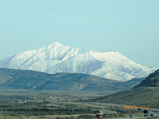
 After leaving St. George, Utah we traveled up in elevation over 2000 ft. and this is what we encountered. A few days earlier, there was a severe snow storm in the area and it left a lot of snow in the mountains. The roads were perfect and the scenery was spectacular but this was just a reminder that winter was still around and was not going to go away just yet.

 Just outside of Salt Lake City it was evident that this is a big city with lots of of people and lots of traffic. The Interstate 5 and the freeway system has greatly improved over the years but  also the population has increased tremendously. This is not the place to pull a big trailer through during rush hour or you could be waiting a long time.
 We stayed in a campground in Idaho Falls for the evening and left early on March 6th and caught a spectacular view of the early morning sunrise. It was so beautiful and peaceful to travel at this time of morning. Sort of makes coming home a little more entertaining.


March 6th 2015, we cross the Canadian border at Coutts. It is good to be back home in our beautiful country.


As we arrive closer to home we both are feeling excited about home.

As we reflect back on this once in a life time, bucket list trip we feel so grateful to have experienced this amazing journey. So many fun adventures, spectacular memories and wonderful people. We feel very blessed and thank God for guiding us, protecting us and keeping us safe through out our entire journey. Reflecting back on our journey is some interesting facts. We traveled through 7 provinces, 32 states and 19,000 miles, we left home August 1st, 2014 and arrived back March 6, 2015 for a total of  8 months in a trailer and we survived to tell the story.

Sunday, March 1, 2015

The Journey Home, March 2015


Making our way back home...
Our journey that we embarked upon On Aug 1st, 2014 is slowly coming to an end. After spending some time in Apache Junction, Phoenix we are now heading north towards home.  We left Phoenix on February 26th and drove to Bullhead City, Arizona to spend a day visiting with relatives. The signage picture was taken in Kingman, Arizona.


Driving to Bullhead City we always enjoy seeing the rock formation that resembles a middle finger sticking up to the sky.   


Nevada Solar One.jpg
Photograph of Nevada Solar One, with the Las Vegas Valley beyond the mountains behind it. Highway 95 running beside the solar plants.


Just before entering Las Vegas on Highway 95 we saw a solar panel plant. Nevada Solar One is a concentrated solar power plant, with a nominal capacity of 64 MW and maximum steam turbine power output up to 74 MW, spread over an area of 400 acres (160 ha). The projected CO2 emissions avoided is equivalent to taking approximately 20,000 cars off the road annually. The project required an investment of $266 million USD, and the project officially went to operation in June 2007. Electricity production is estimated to be 134 million kilowatt hours per year. It is the second solar thermal energy (STE) power plant built in the United States in more than 16 years, and the largest STE plant built in the world since 1991. It is located in Eldorado Valley in the southwest fringe of Boulder City, Nevada, and was built in that city's Energy Resource Zone, which requires renewable generation as part of plant development permits.


And across Highway 95 from the solar panel plant is miles and miles of high tension electrical poles, supplying electricity to Las Vegas and area.
Driving into Las Vegas, NV 

The 2013 population of the Las Vegas metropolitan area was 2,027,828. The city is one of the top three leading destinations in the United States for conventions, business, and meetings and is one of the wealthiest major cities in the country. In addition, the city's metropolitan area has more AAA Five Diamond hotels than any other city in the world, and is a global leader in the hospitality industry. Today, Las Vegas is one of the top tourist destinations in the world. Located on the basin floor of the Mojave Desert it is surrounded by mountain ranges on all sides.


Travelling on the Interstate 15 between Mesquite, NV and St. George UT.


We are staying at a park in St. George, Utah which  is a city located in the southwestern part of the U.S. state of Utah on the Utah-Arizona, Nevada border. The city lies in the northeastern-most stretch of the Mojave Desert, 117 miles (188 km) northeast of Las Vegas, Nevada and 303 miles (488 km) south-southwest of Salt Lake City on Interstate 15.


 Today we visited Snow Canyon State Park, a 7,400 acre scenic park tucked amid lava flows and soaring sandstone cliffs in strikingly colorful desert environment. Sand dunes, up to 2,500 feet thick, eventually cemented into stone. Burnt orange to creamy white color in color, Navajo sandstone, the predominant rock in the park, is what remains of the ancient desert sea. Over time, water cut and shaped the sandstone to form canyons. Cinder cones erupted causing lava to flow down these canyons filling them with basalt.
 
 Throughout the park you can see lava boulders.

 Beautiful views of the canyons in orange to creamy white Navajo rock.


 On our way out of the park you can see the fresh snow on the mountains surrounding St. George.

Friday, February 6, 2015

Phoenix, Arizona - Jan- Feb, 2015

Phoenix is Arizona's state capital. When people refer to Phoenix, they are often referring to the Greater Phoenix area, which includes more than 25 cities and towns. Over the past two decades Phoenix has been one of the fastest growing cities in the country. The 2013 population was 1.51 million and is the sixth largest city in the United States.

 - © Doug Sherman, used with permission.

The saguaro is found only in the Sonoran Desert, which includes about 120,000 square miles of California and Arizona. Most of Baja California and half of the state of Sonora, Mexico is also included. You won't find saguaros above an elevation of about 3,500 feet since they can't handle much frost. A saguaro's arms usually begin to grow only after it is about 15 feet tall and around 75 years old and they can have many arms. Saguaros can grow to over 50 feet tall, the tallest saguaros are about 200 years old and have more than 50 arms.
This photo is of a saguaro cactus at Bartlett Lake in Arizona. That lake is actually the closest lake to the Greater Phoenix area. It's about 22 miles east of Carefree. The photo was taken by a professional landscape photographer, from Cottonwood, Arizona. It was taken on April 5, 2013.   This saguaro has forty-four arms visible in the image and has well over fifty as the back side was not counted. 


Saguaro Cactus - Saguaro Cactus © Judy HeddingSaguaro Cactus Flowers - © Judy Hedding
The saguaro flowers once every year, typically in May and June. Not all the saguaro cactus flowers bloom at the same time; several per day will bloom over the period of a few weeks. Saguaro blooms open at night and last through the next midday.


The sunsets in the desert are spectacular.


Staying in the eastern part of Phoenix, we are in Apache Junction, has it's appeal because this is the last small city and then the landscape changes into rural desert. We are 5 minutes from the desert and 10 minutes from the base of the Superstition Mountains, where you can enjoy beautiful scenery, tranquility and great hiking.  


This is the view from the parking lot of the hike we went on to the Wind Cave.


This is the view once we hiked the 860 ft elevation climb up the mountain to the cave. You get to enjoy a panoramic view of the Phoenix valley. In the distance, to the left you can see the skyline of Phoenix.


There are fruit pickers (volunteers) from our park that go out every Thursday and pick fruit in the Phoenix valley. They donate half of their fruit pickings to the food bank and the remaining  fruit is brought back to the park for everyone to enjoy. All you have to do is fill up a bag and make a small donation for their gas costs.  The citrus is so delicious, and so sweet.


A big pool and hot tub in our park, the pool temperature is kept at kept at 85 - 88 degrees. The weather has been very nice, with daily average temperatures of 80 -82 degrees.
 
 We met a very nice gentleman who kindly took us pecan picking in Queen Creek,  just 10 miles from our park. He knows people who have some land with pecan trees on them and they let us come and pick the pecan. Lots of pecans were on the ground and lots were still on the trees. We used a 15-20 ft pole and swatted the trees and the pecans fell to the ground. We filled up a 5 gallon bucket full of pecans. Now comes the fun part, shelling these delicate nuts. Hopefully, we will get at least 50%  - 60%  pecans out of the bunch. They taste delicious.


Today we hiked the Peralta Trail, in the Gold Canyon area.  It is a very scenic 2.4 mile hike up a valley with an elevation climb of 1380 ft where you arrive at the saddle and view the valley. You start with a slow climb out of the dirt lot but quickly are  climbing over rock and through stream beds cut from the runoff of the hill. Trail twists and drops into foliage then out up onto pure rock faces. The rock face provides the vantage to look back and over your climb. The last switchbacks set you into the saddle which views your climb but the best is the back side which honors Weavers Needle providing a commanding view over the entire valley into the horizon.